This is our final project. In this project, we use GIS combined with other online information and data to analyze the Los Angeles County station fire in summer 2009. The fire started in August 29th and ended in September 2rd. The fire caused a lot of damage and my study will focus on the following three subjects:
1) In which direction did the fire grow and how much area did the fire cover in different times?
1) In which direction did the fire grow and how much area did the fire cover in different times?
2) What was the population affected by the fire and how many houses were destroyed?
3) Were there many parks destroyed by the fire and did the forests enhance the fire?

First of all, let us look at the picture above named digital elevation model of L.A County station fire. Namely, this picture shows us the relationship between elevation and growth of the fire. The different colors in the background indicate the elevation in L.A County, which is highlighted by a blue line. In the middle of L.A County, there are three ‘patterns’ colored in red, orange, and yellow representing the coverage of the fire in Aug 29th, Aug 30th , and Sept 1st respectively. We can clearly see that the fire went northwest first and then went northeast. This observation generates two questions. Firstly, in our common sense, the fire goes from high to low areas. However, in the picture above, through the three days the fire went north, which has high altitude (in brown and white), and developed little in the southern direction (colored in green basically), which is much lower than north. Secondly, the fire went northwest in the first day and later changed its direction to northeast ---- how did this happen?
For both of the two questions, we may have a brief incomplete answer: Winds! Let me explain in detail. In “Climate of California”, it says “California lies within the zone of prevailing westerlies and on the east side of the semi-permanent high pressure area of the northeast Pacific Ocean. The basic flow in the free air above the State, therefore, is from the west or northwest during most of the year. The several mountain chains within the State, however, are responsible for deflecting these winds and, except for the immediate coast, wind direction is likely to be more a product of local terrain than it is of prevailing circulation.” It appears that the winds were the driving force. The western winds pushed the fire to the east, although the elevation is increasing. Also there were other wind from the east might change the fire’s direction. One is called Santa Ana winds and it just started in Fall. The National Weather Service defines Santa Ana winds as "Strong down slope winds that blow through the mountain passes in southern California. These winds, which can easily exceed 40 mph, are warm and dry and can severely exacerbate brush or forest fires, especially under drought conditions." Santa Ana winds bring dry and warm air, which is ‘perfect’ for the fire. This explains why the fire was quickly expanding.
Another reason the fire was going from low altitude to high is that lower bushes often contain more water while plants in higher areas are often dry and ignited easily.
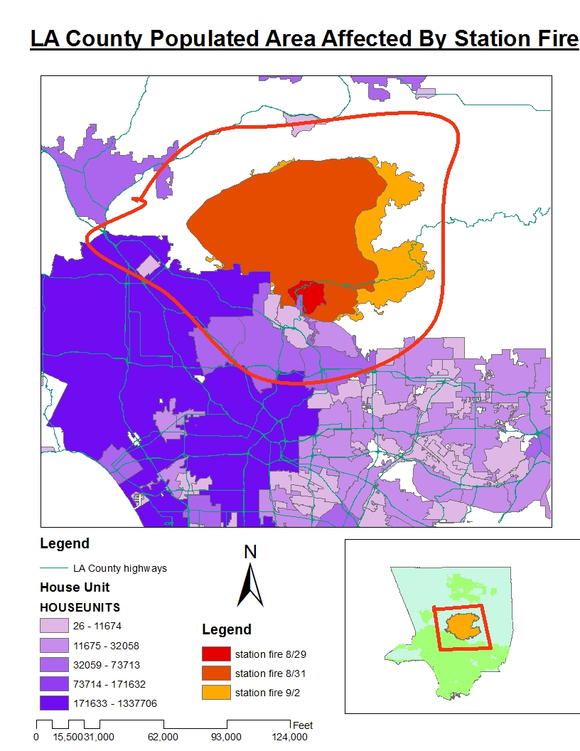
We are very interested in how the fire affected families and houses. Here we have a picture combining the distribution of population/families and the fire coverage. Happily, this time our common sense does not fail ---- People do live in plain areas not mountains! The darker color means more people and vice versa. We can see that most families were in the left lower corner. The fire in different colors means the fire in different times. The red circle is the boundary in which people were affected by the fire. Fortunately, we find only a small portion of people in L.A County were affected by the station fire. At the beginning, the fire was very close to large population area; however, as it grew it went towards north and expanded in a direction where few people were living there. Even though the fire grew in a better way, it must have caused enough panic and fire fighters made great contribution to making sure the fire was away from residents.

Sept. 4, 5:38 a.m.: Before dawn Friday, firefighters build a small memorial to honor Los Angeles County Fire Capt. Tedmund "Ted" Hall, 47, and Firefighter Spc. Arnaldo "Arnie" Quinones, 34, who died Sunday when their truck plunged down a hillside.

Last picture is about fires and parks. Parks might have a negative effect in the station fire because the tree and woods can enhance the fire. Unfortunately, there were many parks around the fire and therefore, the fire went over them and destroyed them. A good way of thinking of this is that more parks means fewer people, thus we thank the parks for bringing the fire away from us.
This concludes this quarter’s projects. I have had a great experience with the GIS map. It not only helps us understand our world better, but also has the potential to save lives in disasters with the analysis.

Sept. 1, 12:08 a.m.: A group of young men watch the Station fire from a hill overlooking Tujunga on Monday night. (Wally Skalij / Los Angeles Times)
On the fire lines
http://www.latimes.com/news/local/la-me-bigpicturefire,0,5985825.htmlstory
http://gis.ats.ucla.edu/ UCLA GIS Data archive
http://egis3.lacounty.gov/dataportal/?tag=lar-iac LA County GIS Data Portal
http://www.usgs.gov/ United States Geological Survey
No comments:
Post a Comment